


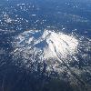
Aerial photo of Mount Shasta Tags: Mount Shasta View |
Tags: Mount Shasta View |
Tags: Mount Shasta View |
|||||||||
Tags: Mount Shasta View |
Tags: Mount Shasta View |
Tags: Mount Shasta View |
|||||||||
Tags: Mount Shasta View |

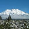


Mount Shasta (�ytaahkoo in Karuk (Karuk language) or "White Mountain") is located in Siskiyou County and at convert14179ftm is the second highest peak in the Cascades (Cascade Range) and the fifth highest (List of California fourteeners) in California. Mount Shasta has an estimated volume of convert85mi3km3 which makes it the most voluminous stratovolcano in the Cascade Volcanic Arc (Cascade Volcanoes).
The mountain and its surrounding area are managed by the U.S. Forest Service, Shasta-Trinity National Forest.
Photo Caption: Aerial view of Mount Shasta from the west
Elevation Ft: 14179
Elevation Ref: NAVD88
Prominence Ft: 9822
Prominence Ref: Ranked 96th (List of peaks by prominence)
Parent Peak: Mount Whitney
Listing: Ultra (Ultra prominent peak)
Birth Location: Siskiyou County, California, Siskiyou County, California, United States, USA
Range: Cascade Range
Coordinates: coord412433.11N1221141.60Wtype:mountain_region:US-CA_source:ngsdisplay=inline,title
Coordinates Ref:
Topo: USGS (United States Geological Survey) Mount Shasta
Type: Stratovolcano
Age: About 593,000 years
Volcanic Arc/belt: Cascade Volcanic Arc (Cascade Volcanoes)
Last Eruption: 1786
First Ascent: 1854 by E. D. Pearce and party
Easiest Route: Avalanche Gulch ("John Muir") route: glacier/snow climb