


Removed dust spots Tags: Mount Rainier View |
Tags: Mount Rainier View |
Tags: Mount Rainier View |
|||||||||
Tags: Mount Rainier, Mount Washington View |
Tags: Mount Rainier View |
Tags: Mount Rainier View |
|||||||||
Tags: Mount Rainier View |


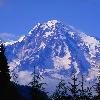
Mount Rainier, or Mount Tahoma, as it is traditionally called, is a large active (Volcano#Active) stratovolcano (also known as a composite volcano) in Pierce County, Washington, USA (United States), located convert54mikm0 southeast of Seattle (Seattle, Washington). It towers over the Cascade Range as the most prominent (Topographic prominence) mountain in the contiguous United States and Cascade Volcanic Arc (Cascade Volcanoes) at convert14411ftm0. It is the highest mountain in Washington and the Cascade Range.
The mountain and the surrounding area are protected within Mount Rainier National Park. With 26 major glaciers and convert36sqmi of permanent snowfields and glaciers, Mount Rainier is the most heavily glaciated peak in the lower 48 states. The summit is topped by two volcanic craters, each over convert1000ftm-2 in diameter with the larger east crater overlapping the west crater. Geothermal (Geothermal (geology)) heat from the volcano keeps areas of both crater rims free of snow and ice, and has formed the worlds largest volcanic glacier cave network within the ice-filled craters. A small crater lake about Convert130by30ftm in size and Convert16ftm0 deep, the highest in North America with a surface elevation of Convert14203ftm0, occupies the lowest portion of the west crater below more than Convert100ftm-1 of ice and is accessible only via the caves.
Mount Rainier has a topographic prominence of convert13211ftm, greater than that of K2 (convert13189ftm). On clear days it dominates the southeastern horizon in most of the Seattle-Tacoma-Bellevue metropolitan area (Seattle metropolitan area) to such an extent that residents sometimes refer to it simply as "the Mountain." On days of exceptional clarity, it can also be seen from as far away as Portland, Oregon, and Victoria, British Columbia.
The Carbon (Carbon River), Puyallup (Puyallup River), Mowich (Mowich River), Nisqually (Nisqually River), and Cowlitz Rivers begin at eponymous glaciers of Mount Rainier. The sources of the White River (White River (Washington)) are Winthrop (Winthrop Glacier), Emmons (Emmons Glacier), and Fryingpan Glaciers. The White, Carbon, and Mowich join the Puyallup River, which discharges into Commencement Bay at Tacoma (Tacoma, Washington); the Nisqually empties into Puget Sound east of Lacey (Lacey, Washington); and the Cowlitz joins the Columbia River between Kelso (Kelso, Washington) and Longview (Longview, Washington).
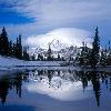
Photo Caption: Mount Rainier as viewed from the northeast.
Elevation Ft: 14411
Elevation Ref:
Prominence Ft: 13211
Prominence Ref: Ranked 21st (List of peaks by prominence)
Map: Washington
Listing: Ultra (Ultra prominent peak),U.S. state high point (List of U.S. states by elevation)
Birth Location: Mount Rainier National Park, Pierce County, Washington, United States, USA
Range: Cascade Range
Lat D: 46 lat_m = 51 lat_s = 10 lat_NS = N
Long D: 121 long_m = 45 long_s = 37 long_EW = W
Coordinates: Coord465110N1214537Wtype:mountain_region:USdisplay=inline
Topo: USGS (United States Geological Survey) Mount Rainier West
Type: Stratovolcano
Age: 500,000 years
Volcanic Arc/belt: Cascade Volcanic Arc (Cascade Volcanoes)
Last Eruption: 1894
First Ascent: 1870 by Hazard Stevens and P. B. Van Trump
Easiest Route: rock/ice climb via Disappointment Cleaver