


The Appalachian Trail crosses the grassy bald area atop Max Patch Mountain, a 4,616-ft (1,407m) summit in the Bald Mountains of the U.S. states of North Carolina and Tennessee. Tags: Max Patch View |
Tags: Max Patch View |
Tags: Max Patch View |
|||||||||
Tags: Max Patch View |
Tags: Max Patch View |
Tags: Max Patch View |
|||||||||
Tags: Max Patch View |
 summit in the Bald Mountains of the U.S. states of North Carolina and Tennessee.")


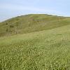
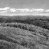

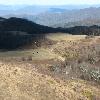
Max Patch is a naturally-occurring bald (Appalachian balds) mountain on the North Carolina-Tennessee Border in Madison County, North Carolina and Cocke County, Tennessee. It is a major landmark along the Tennessee/North Carolina section of the Appalachian Trail, although its summit is located in North Carolina. It is known for its 360 degree views of the surrounding mountains, namely the Bald Mountains in the immediate vicinity, the Unakas (Unaka Range) to the north, the Great Smokies (Great Smoky Mountains) to the south, and the Great Balsams (Great Balsam Mountains) and Black Mountains (Black Mountains (North Carolina)) to the southeast. While the mountain was originally bald naturally for unknown reasons, today the summit is kept clear of trees by mechanical mowing. A small parking area is located near the summit with a short loop trail.
The mountain received national publicity after Bethany Lott was killed when struck by lightning near the summit as she was about to be proposed to by Richard Butler on June 8, 2010.cite weblast=Jamesfirst=Susan Donaldsontitle=Fiancee Killed by Lightning During Surprise Wedding Proposalurl=Newsaccessdate=9 June 2010
Photo Caption: Max Patch Bald
Elevation Ft: 4,616
Birth Location: Madison County, North Carolina, Madison County, North Carolina, USA
Range: Bald Mountains
Coordinates: coord35.79705N82.95681Wtype:mountain_region:US-NC display=inline,title
Topo: USGS (United States Geological Survey) Lemon Gap