


Mile marker 0 on Michigan State Highway M-185, Mackinac Island, Michigan. Taken by me in August 2004. Tags: Mackinac Island View |
Tags: Mackinac Island View |
Tags: Mackinac Island View |
|||||||||

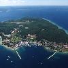
Mackinac Island (pronEng?m�k?n?? respellMAKin-aw) is an island covering Convert3.8sqmikm21 in land area, part of the U.S. state of Michigan. It is located in Lake Huron, at the eastern end of the Straits of Mackinac, between the states Upper (Upper Peninsula of Michigan) and Lower Peninsulas (Lower Peninsula of Michigan). The island was home to a Native American settlement before European exploration began in the 17th century. It served a strategic position amidst the commerce of the Great Lakes fur trade. This led to the establishment of Fort Mackinac on the island by the British (Kingdom of Great Britain) during the American Revolutionary War. It was the scene of two battles during the War of 1812.
In the late 19th century, Mackinac Island became a popular tourist attraction and summer colony. Much of the island has undergone extensive historical preservation and restoration; as a result, the entire island is listed as a National Historic Landmark. It is well known for its numerous cultural events; its wide variety of architectural styles, including the famous Victorian (Victorian architecture) Grand Hotel (Grand Hotel (Mackinac Island)); its fudge; and its ban on almost all motor vehicles. More than 80 percent of the island is preserved as Mackinac Island State Park.
Image Name: Mackinac_Island_topographic_map-en.svg
Image Caption: Topographic map of Mackinac island
Locator Map: location mapMichiganlabel=Mackinac Islandmark=Green pog.svglat_dir=Nlat_deg=45lat_min=51lat_sec=40lon_dir=Wlon_deg=84lon_min=37lon_sec=50
Map Custom: yes
Native Name: Michilimackinac
Native Name Link: Menominee language
Birth Location: Mackinac Island, Michigan, Lake Huron
Coordinates: Coord455140N843750Wtype:isle_region:US-MIdisplay=inline,title
Total Islands: Three
Major Islands: Mackinac, Bois Blanc (Bois Blanc Township, Michigan), Round (Round Island (Michigan))
Area: convert3.776sqmikm23abbr=on
Coastline: convert8mikmabbr=on
Highest Mount: Fort Holmes
Elevation: convert890ftm0disp=/abbr=on
Population: 523 residents and as many as 15,000 tourists per day during peak season
Population As Of: 2000
Density: 53.48
Ethnic Groups: Infobox_nrhp name =Mackinac Island
Nrhp Type: nhld
Lat Degrees: 45
Lat Minutes: 51
Lat Seconds: 45
Lat Direction: N
Long Degrees: 84
Long Minutes: 37
Long Seconds: 51
Long Direction: W
Architect: Unknown
Architecture: No Style Listed
Designated Nrhp Type: October 9, 1960
Added: October 15, 1966
Refnum: 66000397