


Mackinac Bridge, Sunset, 2008 Tags: Mackinac Bridge View |
Tags: Mackinac Bridge View |
Tags: Mackinac Bridge View |
|||||||||

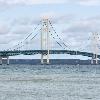
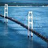
The Mackinac Bridge (pronEng?m�k?n??, respellMAKin-aw), is a suspension bridge spanning the Straits of Mackinac to connect the non-contiguous Upper (Upper Peninsula of Michigan) and Lower (Lower Peninsula of Michigan) peninsulas of the U.S. state of Michigan. Envisioned since the 1880s, the bridge was completed in 1957 only after many decades of struggles to begin construction. Designed by engineer David B. Steinman, the bridge (familiarly known as "Big Mac" and "Mighty Mac") connects the city of St. Ignace (St. Ignace, Michigan) on the north end with the village of Mackinaw City (Mackinaw City, Michigan) on the south. It is the longest suspension bridge between anchorages in the Western hemisphere.
Bridge Name: Mackinac Bridge
Also Known As: ''Mighty Mac'' or ''Big Mac''
Carries: 4 lanes of jctstate=MII75
Crosses: Straits of Mackinac
Locale: Mackinaw City (Mackinaw City, Michigan) and St. Ignace (St. Ignace, Michigan), Michigan
Maint: Mackinac Bridge Authority
Design: Suspension bridge
Mainspan: convert3800ftm0
Length: convert26372ftm0
Height: 5.52 Mtr
Clearance: convert200ftm0
Below: convert155ftm0
Traffic: 11,600
Toll: $1.75 per axle for passenger vehicles ($3.50 per car). $3.50 per axle for motor homes. $4.50 per axle for commercial vehicles.
Map Cue: Connects:
Map Image: MackinacBridge.svg
Map Text: Mackinaw City (Mackinaw City, Michigan) and St. Ignace (St. Ignace, Michigan)
Coordinates: Coord45.816558333-84.72769444region:US-MI_type:landmarkdisplay=inline,title