


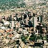
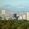

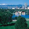
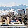
The City and County of Denver (pronounced IPA-en?d?nv?r) is the capital (Capital (political)) and the most populous city (Colorado municipalities) of the U.S. state of Colorado. Denver is a consolidated city-county, located in the South Platte River Valley (South Platte River) on the High Plains (High Plains (United States)), just east of the Front Range of the Rocky Mountains. The Denver downtown district is located immediately east of the confluence of Cherry Creek (Cherry Creek (Colorado)) with the South Platte River, approximately convert12.8mikm0sp=us east of the foothills of the Rocky Mountains. Denver is nickname (List of city nicknames in the United States)d the "Mile-High City" because its elevation is one mile, or convert5280ft0 above sea level,. The 105th meridian west of Greenwich (105th meridian west) passes through Union Station (Union Station (Denver, Colorado)) and is the temporal reference for the Mountain Time Zone.
The United States Census Bureau estimated that the population of Denver was 610,345 in 2009, making it the 24th most populous U.S. city (list of United States cities by population). The 10-county Denver-Aurora-Broomfield, CO Metropolitan Statistical Area had an estimated 2009 population of 2,552,195 and ranked as the 21st most populous U.S. metropolitan statistical area (Table of United States Metropolitan Statistical Areas) and the 12-county Denver-Aurora-Boulder Combined Statistical Area had an estimated 2009 population of 3,110,436 and ranked as the 16th most populous U.S. metropolitan area (Table of United States primary census statistical areas). It is the largest city within a convert500mi-1adj=on radius and the second-largest city in the Mountain West (Mountain States) after Phoenix (Phoenix, Arizona). Denver is the largest city in the Front Range Urban Corridor, an urban region stretching across eighteen counties in two states. The population of the Front Range Urban Corridor was estimated to be 4,328,406 in 2009. The city has the tenth-largest central business district (Downtown Denver) in the United States by population.
Allias Name: The Mile-High City, Queen City of the Plains, Wall Street of the West
Settlement Type: City-county (Consolidated city-county)
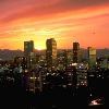
Image Skyline: Montage Denver.jpg
Image Flag: Flag of Denver, Colorado.svg
Image Seal: DenverCOseal.gif
Image Map: Map_of_Colorado_highlighting_Denver_County_(colored).svg
Mapsize: 250x
Map Caption: Location of Denver in the State of Colorado
Pushpin Map: USA
Pushpin Map Caption: Location in the United States
Coordinates Region: US-X
Subdivision Type: Country (List of countries)
Subdivision Name: United States
Subdivision Type1: State (Political divisions of the United States)
Subdivision Name1: flagColoradoname=Colorado
Subdivision Type2: City and County (Colorado municipalities#Consolidated City and County)
Subdivision Name2: Denver
Leader Title: Mayor
Leader Name: John Hickenlooper (D (Democratic Party (United States)))
Established Title: Founded (plat)
Established Date: 1858-11-22, as Denver City, K.T. (Kansas Territory)
Established Title2: Incorporated (municipal corporation)
Established Date2: 1861-11-07, as Denver City, C.T. (Colorado Territory)
Established Title3: Consolidated (consolidated city-county)
Established Date3: 1902-11-15, as the City and County of Denver
Named For: James William Denver
Unit Pref: Imperial
Area Footnotes:
Area Total Km2: 401.3
Area Land Km2: 397.2
Area Water Km2: 4.1
Area Total Sq Mi: 154.9
Area Land Sq Mi: 153.3
Area Water Sq Mi: 1.6
Area Water Percent: 1.03
Area Metro Sq Mi: 8414.4
Population As Of: 2009
Population Total: 610345
Population Density Km2: 1507
Population Density Sq Mi: 3905
Population Metro: 2552195
Population Urban: 1984887
Population Density Urban Sq Mi: 3979.3
Population Blank1 Title: Demonym
Population Blank1: Denverite
Timezone: MST (Mountain Standard Time)
Utc Offset: -7
Timezone Dst: MDT (Mountain Daylight Time)
Utc Offset Dst: -6
Latd: 39 latm = 44 lats = 21 latNS = N
Longd: 104 longm = 59 longs = 5 longEW = W
Coordinates Type: type:city(953987)_region:US-CO_source:gnis-0201738
Coordinates Display: inline,title
Elevation Footnotes:
Elevation M: 1609
Elevation Ft: 5280
Postal Code Type: ZIP codes
Postal Code: 80201-80212, 80214-80239, 80241, 80243-80244, 80246-80252, 80256-80266, 80271, 80273-80274, 80279-80281, 80290-80291, 80293-80295, 80299, 80012, 80014, 80022, 80033, 80123, 80127
Area Code: Both 303 (Area code 303) and 720 (Area code 720)
Blank Name: FIPS code (Federal Information Processing Standard)
Blank Info: 08-20000
Blank1 Name: GNIS feature ID (Geographic Names Information System)
Blank1 Info: 0201738
Blank2 Name: Highways (state highways in Colorado)
Blank2 Info: I-25 (Interstate 25 (Colorado)), I-70 (Interstate 70 (Colorado)), I-76 (Interstate 76 (Colorado)), I-225 (Interstate 225 (Colorado)), I-270 (Interstate 270 (Colorado)), US 6 (U.S. Highway 6 (Colorado)), US 40 (U.S. Highway 40 (Colorado)), US 85 (U.S. Highway 85 (Colorado)), US 285 (U.S. Highway 285 (Colorado)), US 287 (U.S. Highway 287 (Colorado)), CO 2 (Colorado State Highway 2), CO 26 (Colorado State Highway 26), CO 30 (Colorado State Highway 30), CO 35 (Colorado State Highway 35), CO 83 (Colorado State Highway 83), CO 88 (Colorado State Highway 88), CO 95 (Colorado State Highway 95), CO 121 (Colorado State Highway 121), CO 177 (Colorado State Highway 177), CO 265 (Colorado State Highway 265), CO 470 (Colorado State Highway 470), E-470
Website: www.denvergov.org
Footnotes: Most populous Colorado city